I first knew about the hiking trail next to my condo when 1
of Nazhif’s friend shared his photo which overseeing the view of our Altitude
236, located in Persiaran Alam Damai. Little did I know, there is actually a proper hiking trail of 3.62
miles located just behind my condo that I've recently discovered from wikipemia while searching some reference for this entry. No wonder the forest reserve habitats sometimes encroaching nearby our windows since we are neighbors. And the fresh smell of the jungle whenever I open my window is just too good to be true.
 |
| Image download from wikimapia.org-Bukit-Sungai-Besi |
One fine day when Nazhif was still around from his year 1 break, I forced him and Nasrul to accompany me for my mission. I used to see people's passing by from the window of my Level 6 condo and wondering where they were heading to. We can see the first Reservoir from our unit as it seated on the same level. Hubby always scolded me for wearing an obscene dress in our room as he said people walking outside the road could possibly see us. My mission that day was to confirm whether or not our bedroom is visible from the other side. Unfortunately it is actually "yes", though only a little. Imagine if someone sees us through their binoculars?
 |
| I was at "Drain" point in this photo |
 |
| Happy faces with a gorgeous view behind - Cheras side |
It is recommended to start the hike at the junction of Persiaran Aman Damai off Jalan Aman Damai, just next to our Altitude 236. You will pass the two water tanks or reservoirs on the way up. Those 2 water reservoir are visible on satellite imagery as white circles on the first photo. The trail head starts with a tarred road, but only until you reached the second reservoir. From there on, you have to take left side where there is a proper trail leading up. Take note that is a barrier at the trail head that prevents vehicles from entering this area. The path beyond is mostly a bare red soil, some rocks, with occasional landslips that get in the way due to erosion.
 |
| The evidence |
There's nothing to worry about as the trail is quite solid and you will have no difficulties to get around or over it. There are several barren plateaus along the way that provides a good view of the Cheras area, especially in the morning or afternoon. The best time to start is at 6am-7am, after your morning prayer. But we went after Asar or afternoon prayer which gave us so short period of time to enjoy the hike and the view as it was already dark slightly after 7.15pm. Beyond the barren plateaus, you will enter a forest, starting from a huge undergrowth of ferns. The path changes from red soil to fertile black humus. Be careful at that point as there are no clearly mark trails in the forest. The downhill parts can be steep, muddy, and slippery.
 |
| Trail chain for safety reason |
The image in the first photo show 2 or maybe 3 streams that we did not encounter as we merely stopped at the Main Viewpoint. The sky was getting darker at that time and Nazhif started pestering me to go back. But to those who are really into jungle hiking it is highly recommended to use jungle boots and takes on the jungle trek. What we did that day was merely enjoying the scenery at the plateaus. After some photo evidence, we turn back and go home. There's another family around that time too.

For the record, there are four permanent forest reserve areas in Kuala Lumpur that is 2.1ha. in Bukit Lagong, 9.37ha in Bukit Nanas, 14.51ha in Sungai Puteh and the one behind my condo is Sungai Besi forest reserve of 42.29ha. These four are as officially declared by the Forestry Department of Peninsular Malaysia. Bukit Lagong’s area remains unchanged since it was gazetted in 1962, but the forest area in Bukit Nanas, which was gazetted in 1906 with an area of 17ha, has since been reduced in size to 9.37ha as a result of road and infrastructure projects. The Sungai Puteh permanent forest area, gazetted in 1933 with an area of 40ha, is now reduced to 14.51ha whilst the Sungai Besi permanent forest area has seen a loss of 4.71ha since it was gazetted in 1932.
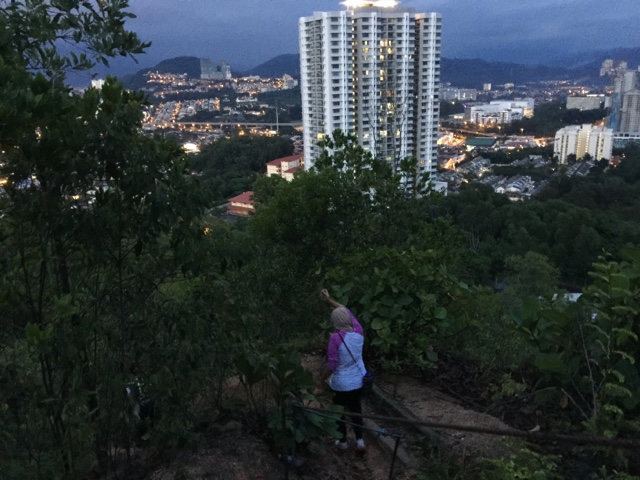
 |
| KL Tower's light was lighted in blue that day. I've been lucky to witness the changing colors of KL Tower every night from my balcony. Indeed, I've been surrounded with enormous bliss. |
Being a quite lazy bump person, the second trip is yet to be arranged. Nevertheless, I hope this entry may help others who takes hiking seriously as hobby and sports.
No comments:
Post a Comment